Canada’s oldest weekly newspaper
© 2026 The Picton Gazette
Since 1830

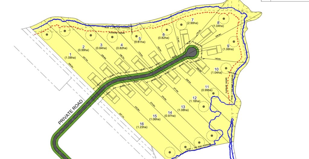
 Concept plan for the proposed subdivision on Half Moon Bay. (Arcadis)
The Flatt Point Subdivision is 22 hectares of woodland, wetland and former farmland.
The property at 3401 County Road 13 is at the tip of Half Moon Bay. Lots are proposed at one hectare (2.5 acres) each, and form a cul-de-sac around a private road. They cover 15 hectares of the 22 hectare parcel.
The developer is seeking an Official Plan Amendment to permit the subdivision and private road. A separate application seeks to establish a right of way to access the property.
“Regardless of what happens with the subdivision they would like private road access,” noted Mark Touw, Principal Planner with the Boulevard Group.
The subdivision application was initially submitted in 2021, just shy of the new Official Plan. As such, it is being analyzed against the 2011 Consolidation of the 2006 Official Plan.
“This was, at that time, an inadequate application,” said Councillor John Hirsch.
”Under the new official plan you wouldn’t be here tonight,” he added, noting that the property falls within one of the County’s Natural Core Areas, protected from development under the 2021 Official Plan.
“Subdivisions are fairly complex sites,” said Mr. Touw in defense of the timing. “It’s usually a multi-year process.”
Some councillors also resisted the notion that the development is in line with the Provincial Planning Statement, which encourages a mix of housing types in settlement areas.
“To me, ‘a mix’ means it’s a mixture of different price ranges and housing styles, which I’m not seeing here,” said Councillor Kate MacNaughton.
“We’re trying to fit a square peg in a round hole right now,” Councillor Sam Branderhorst remarked.
Each property will be set back 50 metres from the water, an extension of the minimum 30-metre requirement.
Mr. Touw noted that Quinte Conservation “identified no objections to the application.”
There are seven hectares of open space and a wetland designated Environmental Protection.
One of the building constraints is the 100-year floodline, which runs along the shoreline within the buffer zone, but dips up into lots 11 and 12.
Michael Toccalino, a retired landscape architect and nearby resident, was skeptical that the buffers were enough to keep the property from flooding.
“In 2017, the water was as high as I’ve ever seen it; where we are over on County Road 13, it was over our shore well,” he said, noting that the Conservation Authority required the shore well to be at the hundred year flood line.
Cheryl Anderson, speaking on behalf of the South Shore Joint Initiative and the Prince Edward Point Bird Observatory, noted that the biodiversity of this part of the South Shore — a migratory path for birds, and habitat to species as risk like the snapping turtle — would be negatively affected by construction, traffic, and light pollution brought on by the development.
“This piece and every piece of the South Shore is important,” Ms. Anderson said. “This is a bad look for a County that is committed to being environmentally responsible.”
By the end of the meeting, Council also remained unconvinced.
“When I looked through the PPS I saw nothing but language that would be contradictory to this development,” said Councillor MacNaughton. “The language in its entirety almost seems to restrict this location.”
If it goes through, she noted that she would like to see “protective clauses and protective options for vegetation, a small footprint, and a high standard of environmental consideration.”
The application will come before the Planning and Development Committee again for decision.
See it in the newspaper


